Selecting Places From the Atlas

Contents
At various places in the program, you are required to enter place details. This is necessary, for example, when you are
• |
Casting a new chart |
• |
Creating a relocation interpretations report |
• |
Relocating a chart. |
• |
Adding a city to the current city file |
It is possible to retrieve city details from the ACS Atlas instead of having to enter all the details (name, latitude, longitude and timezone) each time that you want to use that city location.
>> |
To select stored city details |
Click on the “Place...” button.
This will display the “ACS PC Atlas” dialog box.
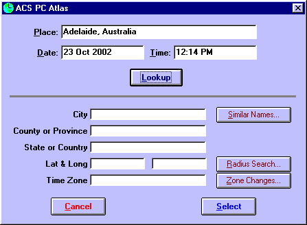
When this screen appears, the place, country, date and time boxes will contain the information that was held on the previous screen. You have the option of changing any of these if you wish to, and then clicking on any of the four main command buttons, which are described below. When you have found the place that you require, then clicking on the “OK” button will return you to the previous screen, and the displayed place details will be copied automatically onto that screen.
Topic Categories