Selecting Map Options

Contents
Any map in Solar Maps may be customised in various ways, for example showing major lakes and rivers, state borders and labelling various cities. Also the projection of the map may be changed to any of 4 pre-defined options, including ÔÇťflatÔÇŁ and circular views, and lines of longitude and latitude may be added.
>> |
To select or change map display options |
Select the ÔÇťMap Options...ÔÇť item from the ÔÇťMapsÔÇť menu.
This will display the ÔÇťSelect Map OptionsÔÇŁ dialog box.
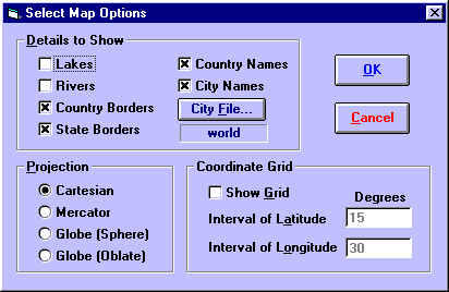
This dialog box contains three categories of options, which are
ÔÇó |
Details to Show - What kind of features to include on the map |
ÔÇó |
Projection - In what form to display the map |
ÔÇó |
Coordinate Grid - Whether to display reference lines of latitude and longitude |
Topic Categories