Displaying Lines

Contents
There are a number of different astrological line types which it is possible to display in relation to the currently selected chart.
>> |
To select which line types to display on the current map |
Select the ŌĆ£Displayed Lines...ŌĆ£ item from the ŌĆ£ChartŌĆ£ menu or click on the ŌĆ£LinesŌĆ£ button above the map display area.
This will display the ŌĆ£Select LinesŌĆØ dialog box, which contains a list of the different line types which may be selected for display.
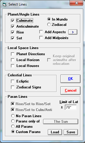
There are four categories of line types which may be selected. These are...
ŌĆó |
Planet/Angle Lines - These are the lines which describe where on the Earth individual planets or stars are culminating or anticulminating (or on the Midheaven and Imum Coeli) or are rising or setting (or on the Ascendant or Descendant). These lines are also sometimes called Astro*Carto*Graphy® lines in other books and programs. The culminating, anticulminating, MC and IC lines are always lines of longitude, whereas the rising, setting, Ascendant and Descendant lines are great circles around the globe and appear to curve on a map viewed in Cartesian or Mercator projection. Extra options allow you to display lines where planets are in aspect to the angles, or alternatively where planetary midpoints conjunct the angles.
|
ŌĆó |
Paran Lines - These are lines of latitude, indicating where any two astronomical bodies (eg. planets or stars) are in an angular relationship which coincides with the meridian and horizon of a chart at that latitude. For example, if the angle between the Sun and Saturn is the same as that between the meridian and the western horizon, for a particular latitude, then there is a paran line for the Sun Culminating/Saturn Setting along that latitude.
|
ŌĆó |
Local Space Lines - These are the lines indicating the direction in which planets or stars are found when looking from the chartŌĆÖs location. These lines are great circles around the globe, starting from the chartŌĆÖs location. The common convention is to continue the line right around the world, back to the starting location. When viewed in Cartesian or Mercator projection, these lines generally appear to curve.
|
ŌĆó |
Celestial Lines - These are projections of the celestial sphere onto the EarthŌĆÖs surface, and show where the ecliptic is overhead, as well as where the zodiacal sign divisions falls onto the EarthsŌĆÖ surface. |
>> |
To switch on or off any particular line type |
Click on the check box to the left of the desired line type.
When any box is checked, that line type is switched on. If it is unchecked (ie. blank), then that line type is switched off.
>> |
To switch on or off a whole category of line types |
Double-click on any empty space inside the frame of a line category.
If all the lines in that category are already off, then this will switch them all on, and vice-versa. If only some lines in that category are already on, then all of them will be switched on. This shortcut enables you to quickly switch on or off whole categories of line types. For example, you may often want to switch on or off all the line types in the Planet/Angle Lines category at one time.
Note that, whilst it is possible to switch on any number of line types at any one time, doing so whilst viewing a world map with all planets displayed would result in a grossly overcrowded display. It is therefore recommended that you use only a limited number of line types whilst viewing large area maps. However, when viewing small area maps, such as individual countries, and/or using only a small number of displayed points, you may find that you can switch on many different line types without causing an overcrowded display.
Following is a description of each individual line type that may be switched on or off.
Planet/Angle Lines - In Mundo
ŌĆó |
Culminate Lines - These lines show where a planet (or star) would be crossing the meridian, at the highest point of its diurnal motion. At some point on this line, the planet is exactly overhead. |
ŌĆó |
Anticulminate Lines - These lines show where a planet (or star) would be at the lowest point of its diurnal motion. |
ŌĆó |
Rise Lines - These lines show where a planet (or star) would be crossing the horizon, upwards. |
ŌĆó |
Set Lines - These lines show where a planet (or star) would be crossing the horizon, downwards. |
Planet/Angle Lines - Zodiacal
ŌĆó |
MC Lines - These lines show where a planet (or star) would be conjunct the Midheaven (by zodiacal longitude). |
ŌĆó |
IC Lines - These lines show where a planet (or star) would be conjunct the Imum Coeli (by zodiacal longitude). |
ŌĆó |
Asc Lines - These lines show where a planet (or star) would be conjunct the Ascendant of a chart (by zodiacal longitude). |
ŌĆó |
Dsc Lines - These lines show where a planet (or star) would be conjunct the Descendant of a chart (by zodiacal longitude). |
The Culminate/Anticulminate/Rise/Set lines are identical to the MC/IC/Asc/Dsc lines for bodies which are exactly on the ecliptic. Most planets are close to the ecliptic, but Pluto, some asteroids and most stars are not. Standard Astro*Carto*Graphy® uses the In Mundo lines, but you may prefer to use Zodiacal lines if you want to relate the lines that you see to planets being exactly conjunct the angles of the chart.
It is not possible to view both In Mundo and Zodiacal lines at the same time.
>> |
To switch between viewing In Mundo and Zodiacal lines |
Select the required ŌĆ£In MundoŌĆ£ or ŌĆ£ZodiacalŌĆ£ option button.
Planet/Angle Aspect Lines
>> |
To switch on Aspect Lines |
Click on the ŌĆ£Add AspectsŌĆØ check box.
Normally, the planet/angle lines displayed are only conjunctions to the chart angles (MC, IC, Asc, Dsc or Culmination, Anti-culmination, Rising, Setting). However, when you use the Add Aspects options, you are able to see additional lines for aspects other than just conjunctions, such as trines, squares, sextiles to each of the angles.
>> |
To select which aspects to include |
Click on the ŌĆ£>ŌĆØ button to the right of the ŌĆ£Add AspectsŌĆØ button.
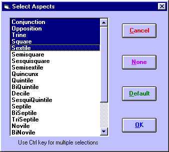
This displays a dialog which allows you to highlight which aspects you wish to include. The list includes all possible aspects from the 1st to the 12th harmonic types. Clicking on the ŌĆ£DefaultŌĆØ button will select the first five major aspects on the list, and clicking on the ŌĆ£NoneŌĆØ button will switch off the Add Aspects option.
Note: Certain aspects are complimentary to one another when used with pairs of chart angles eg. a conjunction to the MC and an opposition to the IC would be identical lines. Also, a trine to the MC and a sextile to the IC are also identical lines. Solar Maps contains an algorithm that automatically discards such identical lines, in order to avoid the confusion that might arise if they were all plotted. Therefore, if you choose both conjunctions and oppositions and both MC and IC, then only conjunctions to each will be displayed. Similarly, if you choose both trines and sextiles, then only trines to each will be displayed. However, if you choose both trines and sextiles but select only the MC and not the IC, then you will see both trines and sextiles to the MC, because in this case the sextiles are not replicating the trines to the IC that would have been shown if the IC was also selected.
Note: Using this option will result in a very large number of lines being displayed on a world map. It is recommended that you use this option only with regional maps.
Planet/Angle Midpoint Lines
>> |
To switch on Midpoint Lines |
Click on the ŌĆ£Add MidpointsŌĆØ check box.
When this option is selected, lines are drawn for each possible midpoint combination of all the selected displayed chart points. You can control which points are included by selecting a particular subset of Displayed Points by using the appropriate option from the Chart menu.
Note: The method of calculating the midpoint positions depends on whether the ŌĆ£In MundoŌĆØ or ŌĆ£ZodiacalŌĆØ option is selected. When the ŌĆ£In MundoŌĆØ option is selected, the midpoint lines are midpoints in right ascension, whereas when the ŌĆ£ZodiacalŌĆØ option is chosen, the midpoints are midpoints in ecliptical longitude.
Note: Using this option will result in a very large number of lines being displayed on a world map. It is recommended that you use this option only with regional maps.
Paran Lines
ŌĆó |
Rise/Set to Rise/Set - These lines show at what latitude pairs of planets (or stars) rise/rise, rise/set, set/rise or set/set at the same time. |
ŌĆó |
Rise/Set to Culm/Anti - These lines show at what latitudes pairs of planets either rise/culminate, rise/anticulminate, set/culminate or set/anticulminate. |
It is possible to see parans for one planet or star at a time (paired with each other planet or star), or for all planets and stars together. The latter option produces a large number of lines, and it is recommended that this option be used only on regional maps or maps of small areas.
>> |
To choose which planet or star to view the parans of |
1. |
Click on the ŌĆ£Parans Of...ŌĆ£ button. |
2. |
Select an Item from the list of currently displayed points. |
To view parans of a star, you must first have opened a star file. See Opening a Star File for instructions on how to do this. Note that the point which you choose does not have to be a displayed point. You can view parans of any point, regardless of whether or not you have selected it as a displayed point.
To prevent unwanted paran lines from being displayed, it is also possible to limit the latitudes between which paran lines will be shown.
See Selecting Custom Paran Lines for working with one or a subset of paran lines at a time, and saving your own sets of paran lines.
>> |
To specify a latitudinal limit |
Enter a ŌĆ£Limit of LatŌĆ£ value in whole degrees.
The entered value must be between 45 and 90 degrees. Paran lines will not be displayed beyond the specified latitudes, both north and south. Typically you may want to use a value of 60 degrees or so, because lines in the arctic and antarctic region are of little interest to most people who live and travel in less extreme latitudes.
Local Space Lines
ŌĆó |
Planet Directions - These lines extend from the chart location toward each planet (or star) according to its local azimuth, and extend around the globe. |
ŌĆó |
Local Horizon - This line indicates where planets or stars would be on the horizon in relation to the current chartŌĆÖs location. Astronomical points between the chart and this line would be above the horizon (and potentially visible), whereas those on the other side of the line would be below the horizon (and therefore not visible). |
ŌĆó |
Local Houses - These lines are a division of the local space into 12 equal houses of 30┬║ azimuth each. The 1st house cusp is always due east, and the 10th house cusp is south for chart locations north of the ecliptic, and north for chart locations south of the ecliptic. |
Normally, the planet direction lines (ie. planet azimuths) change whenever the chartŌĆÖs location is changed. However, there is an option which allows you to keep the original azimuths intact despite relocating the chart. Hence, with this option switched on, you can relocate your chart, and display planet direction lines emanating from that new location, but with directions corresponding to the original natal directions rather than the directions that would apply if you had actually been born at that new location. (Note that in this case, the planet direction lines will no longer intersect the points where the planets are actually overhead.)
>> |
To retain the original planet azimuths |
Click on the ŌĆ£Keep original azimuths after relocationŌĆØ checkbox.
This option applies to any relocated chart which are relocated using Solar Maps relocation options, including any charts that were relocated prior to selecting this option.
Note: This option has no effect on any charts which were already relocated externally to Solar Maps (such as in Solar Fire) ŌĆō Solar Maps does not recognise such charts as being relocated ŌĆō rather they are treated as ordinary natal charts.
Celestial Lines
ŌĆó |
Ecliptic - This is the projection of the ecliptic onto the EarthŌĆÖs surface. The sun is always overhead somewhere on this line, and most of the other planets are near it. The ecliptic is inclined to the EarthŌĆÖs equator, and extends about 23.5┬║ north and south of it. |
ŌĆó |
Zodiacal Signs - These lines are the projection of the lines of zodiacal longitude which divide the ecliptic into 12 equal zodiacal signs. Therefore they all cross the ecliptic at right angles. |
See Introduction to Astro-locality Mapping for a further discussion of line types and how they are used in astro-locality mapping.