Casting a New Chart

Contents
It is possible to cast new natal or event charts for subsequent display, and any such charts may also be saved to a chart file for later re-use.
>> To cast a new chart
Select the “New Chart..“ option from the “Chart“ menu.
This will display the “New Chart Data Entry” dialog box.
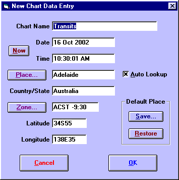
You may enter all the required details on this screen. These details are
• |
Chart Name - Enter up to 30 characters to describe the chart. Typically this is the name of the person for whom you are casting the chart. This must not be left blank. |
• |
Date - Enter the date for the chart. Most normally used date formats are acceptable. See Entering Dates for a description of valid date formats. |
• |
Time - Enter the local time for the chart. Most normally used time formats are acceptable. See Entering Times for a description of valid time formats. You must enter a time, even if the actual time of birth is not known. If so, then the best solution is normally to enter a time of 12 PM. |
• |
Place - Enter the name of the place for the chart. Alternatively you can click on the place button or use the AutoLookup feature to get the required place details from the Atlas. |
• |
Country/State - Enter the name of the country or state in which the place exists. |
• |
Zone - Enter a timezone abbreviation and/or time difference. See Entering Time Zones for a description of valid timezone formats. |
• |
Latitude - Enter the latitude of the chart location. See Entering Latitudes and Longitudes for a description of valid latitude formats. |
• |
Longitude - Enter the longitude of the chart location. See Entering Latitudes and Longitudes for a description of valid longitude formats. |
The buttons may be used as follows
• |
Now - Fills in the Chart Name, Date and Time fields according to the computer’s internal clock. If the computer’s clock is not accurately set, then you can use the control panel’s Date/Time icon to reset it. |
• |
Place - Displays the Select City (or ACS PC Atlas) screen from which place details may be selected. See Selecting Places From the Atlas for a full description of the atlas features. |
• |
Zone - Displays the TimeZone Selection screen from which a timezone may be selected. See Entering Time Zones for more details. |
• |
Save - Saves the current Place, Country/State, Zone, Latitude and Longitude as the default. |
• |
Restore - Restores the Place, Country/State, Zone, Latitude and Longitude which were last saved as the default with the Save button. |
If the "AutoLookup" checkbox is checked, then as soon as the cursor leaves the Country/State field, the atlas is automatically searched for a match with the Place and Country/State name that were entered. If a match is found, then the Zone, Latitude and Longitude fields are automatically filled in with the appropriate details.