Selecting a Tracking Event to Display

Contents
>> |
To select a track or event from the collection file |
Select the “Select Tracking Event…“ item from the “Track“ menu.
This will display the “Select Plotting Events” dialog, displaying a list of tracks or events from which you can choose.
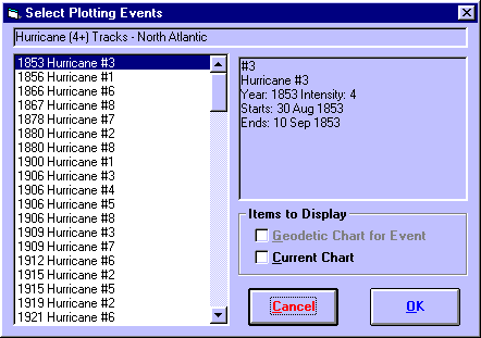
When you click on a track in the listbox on the left, the details of that track or event will be displayed in the box at the right.
Additionally, you may select which of the following items to display by clicking on their check boxes.
• |
Geodetic Chart for Event - If selected, this will calculate the chart for the time of the event and display it geodetically. For an explanation of geodetic charts, see Selecting Zodiac Projection Type. |
• |
Current Chart - If selected, the currently displayed chart will be retained and plotted at the same time as the track or event markers. |
>> |
To select one of these tracks or events to display |
Click on the required track and then click on the “OK“ button or Double-click on the required track.
You will then be returned to the main screen of Solar Maps, and the newly selected track will be drawn onto the current map. If you have selected a single track or event, then that event location (or the first location of the track) will be highlighted with a expanding/contracting circle (provided that it is visible on the current map region).
In some circumstances it may be interesting to plot multiple tracks or events at once – ie. composite tracks. For example you may wish to plot all the hurricane tracks in a single year, or all the earthquakes in a collection file.
>> |
To select multiple tracks or events at one time |
• |
Hold down the Ctrl key whilst clicking on different list entries, or |
• |
Hold down the Shift key after clicking on one entry, and then click on another elsewhere in the list, or |
• |
Click and drag the mouse over a range of entries |
You will then be returned to the main screen of Solar Maps, and all of the selected tracks or events will be drawn simultaneously onto the current map.