Editing Track or Event List Data

Contents
The track or event data editing dialog is displayed after the “Edit” button is clicked on the “Track or Event Collection” screen.
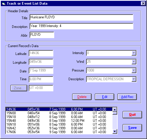
The Header Details consist of the following items.
• |
Title - A brief title which is displayed as part of the caption of a map when a track or event from this file is being displayed. (eg. Hurricane FLOYD) |
• |
Description – A further description which can be seen and used to help the user select individual tracks to plot |
• |
Abbr – An abbreviated title for display in circumstances where the full title would be too long. |
Note that the title, description and abbr fields are disabled if you are editing an event collection (as opposed to a track), because they are not applicable to an event collection.
The Current Record’s Data consists of the following items
The data displayed in the Current Record’s Data frame relate to whichever event is highlighted in the list at the bottom of the dialog. However, it is not editable until the “Edit” or “Add Rec” buttons are used.
• |
Latitude – The geographical latitude of the event or track point. This may be entered as an ordinary latitude, or in decimal degrees (-ve = South). See Entering Latitudes and Longitudes for details on how to enter latitudes. |
• |
Longitude – The geographical latitude of the event or track point. This may be entered as an ordinary longitude, or in decimal degrees (-ve = East). See Entering Latitudes and Longitudes for details on how to enter latitudes. |
• |
Date – The date of the event or track point |
• |
Time – The time of the event or track point |
• |
Zone – The timezone applying to the date and time |
• |
Other Fields –To the right is a list of all the extra data fields which have been selected for the track or event list. The data type which may be entered into each one depends on what type has been pre-selected for that type (ie. Free Text, Numeric or List of Items). For those data types which are Lists of Items, the user may activate the drop-down box to choose one of the items of the list, or alternatively type in an item. If that item is not already on the list, then the user will be asked whether they wish to add it to the list. |
>> |
To Edit the current highlighted record |
Click on the “Edit” button
This will enable all the fields in the Current Record’s Data frame, so that the user may edit them.
After editing, the user must click on either “Save Edits” to accept the changes, or “Cancel” to revert to the original data.
>> |
To Add a new record |
Click on the “Add Rec” button
This will enable all the fields in the Current Record’s Data frame, so that the user may edit them.
After editing, the user must click on either “Save Edits” to accept the changes and add them as a new record, or “Cancel” to prevent it being added.
>> |
To save all edits and additions |
Click on the “Save” button