Editing Countries

Contents
Solar Maps contains a single country file which contains information relating to country names, sizes and locations. It is possible for the user to edit, add or delete entries, and alter the conditions under which certain entries are written onto maps. The country file can also potentially be used to store information on other geographical features such as seas, oceans, desert regions etc. which can all also be plotted onto maps.
>> |
To edit information in the county file |
Select the ÔÇťEdit Countries...ÔÇť item from the ÔÇťMapsÔÇť menu.
This will display the ÔÇťEdit CountriesÔÇŁ dialog box.
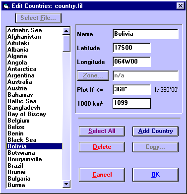
The information that is stored for each entry in the country file is
ÔÇó |
Name - This name is what appears on the map. |
ÔÇó |
Latitude - The latitude at which the name is to be plotted. See Entering Latitudes and Longitudes for a description of valid latitude formats. |
ÔÇó |
Longitude - The longitude at which the name is to be plotted. See Entering Latitudes and Longitudes for a description of valid longitude formats. |
ÔÇó |
Plot If <= - This controls how wide the map must be in order for the name to be plotted. For example, if a value of 100 is entered, then this name will only appear on maps which cover less than 100┬║ of longitudinal width. If its value is set to 360┬║, then the area of the country (1000 km2) is used to determine whether the name is plotted, instead. |
ÔÇó |
1000 km2 - This is the area of the country in thousands of square kilometres. If the Plot If <= field is set to any value other than 360, then this field is ignored. Otherwise this value is used to control whether the name is plotted on maps of various sizes. Names with large areas are plotted on all maps, with medium areas on smaller maps, and with small areas only on the smallest maps. This value may be set to zero if the actual area is unknown, or if the entry relates to a geographical feature which does not have an area. In this case, you can use the Plot If <= field to control on which maps the name is plotted. (Note: 1000km2 is equal to approx 386mi2.) |
Note that the ÔÇťZone...ÔÇť and ÔÇŁCopy...ÔÇť buttons are disabled as they do not apply to the country entries.
>> |
To edit an existing entry in the country file |
1. |
Click on the required entry in the listbox. |
2. |
Edit the information fields. |
These fields are described above.
>> |
To edit multiple entries at once |
1. |
Whilst holding down the ÔÇťCtrlÔÇť key, click on each of the required entries or Click on the ÔÇťSelect AllÔÇť button to select all the entries in the list. |
2. |
Edit the required information fields. |
It is only possible to change the Plot If <= and the 1000 km2 fields simultaneously for multiple entries in the list.
>> |
To add a new entry to the list |
1. |
Click on the ÔÇťAdd CountryÔÇť button. |
2. |
Enter data into the information fields. |
If you change your mind half way through entering new data, you will need to delete this entry.
>> |
To delete one or more entries from the list |
1. |
Click on the desired entry, or whilst holding down the ÔÇťCtrlÔÇť key, click on each of the required entries. |
2. |
Click on the ÔÇťDeleteÔÇť button. |
>> |
In order to exit from this screen |
Click on the ÔÇťOKÔÇť button.
You will be asked whether or not you wish to save the changes that you have made. If you choose to save them, then the entries will be saved and sorted into alphabetical order for next time you use this screen again. If you choose not to save them, then any changes that you made using this screen will be lost.