Saving a Map

Contents
You can save as many maps as you wish. Each map can be saved into its own map file, with a name of your choice. The specific items that are saved when you save a map are...
• |
A description of the map |
• |
The range of latitude and longitude covered by the map |
• |
The map projection |
• |
Which details to show (eg. lakes, rivers, city names etc) |
• |
Coordinate grid options |
• |
City file name |
• |
Color fill points (including any special fill colors that you may have selected) |
>> |
To save the current map |
Select the “Save As...“ item from the “Maps“ menu.
This will display the “Save File As” dialog box.
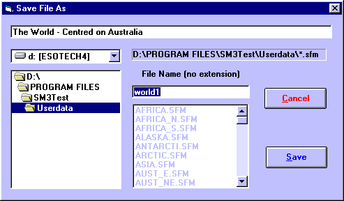
You can enter a description to be saved with the map in the text box at the top of the screen. This description is displayed whenever you browse through the list of maps to open, so it is helpful to enter a useful description which will allow you to see whether this file contains the map that you want. For example you could enter the name of the geographic region covered by the map, plus an indication of the map projection used.
All of the maps must be stored in Solar Maps USERDATA directory in order to be re-opened for future re-use, but if necessary, you can choose a different disk drive by selecting an item from the drop-down list of drive names, and look in a different directory by double-clicking on directory names in the directory list box on the left. For example, you may wish to select the A: drive if you want to save a map to a diskette to send to someone else.
The file name can be entered into the File Name text box.
>> |
To save the map with the displayed name and description |
Click on the “Save“ button.
The map will then be saved, and can be reopened at any time.
Examples of items that are not saved with a map file, and are therefore independent of any individual map are...
• |
The land and sea colors |
• |
The selected chart |
• |
Displayed line types |
• |
Line colors |
• |
Symbol sizes |
• |
Eclipse selections |
• |
Displayed planets |