Eclipse Paths

Contents
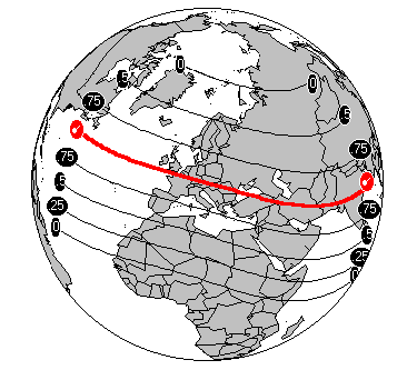
There are typically about four eclipses each year. Two of these are lunar eclipses (©), when the Moon is obscured by the shadow of the Earth. The other two are solar eclipses (¨), when the shadow of the Moon passes across the surface of the Earth. Lunar eclipses can be observed from anywhere on Earth simultaneously, and therefore cannot be plotted onto maps. However, solar eclipses are localised, and can only be seen from certain regions of the Earth. The path of the Moon’s shadow in a solar eclipse is generally very narrow, and forms a thin band which moves across the Earth. This path can be plotted onto a map, as can lines along which the magnitude of the eclipse is less than total.
An Example
On 11th August 1999 a solar eclipse occurred, starting east of the USA, moving across the Atlantic, Europe and the Middle East, finally finishing after passing across India. Astrologers are particularly interested in this eclipse because at the time of the eclipse a powerful fixed grand cross was formed between all the major planets. It was expected that the effect of this eclipse would be felt most strongly in regions directly under the path of total eclipse. Regions which are not under the path of total eclipse but still experiencing a partial eclipse, such as northern Africa, Scandinavia, Russia and China, are likely to be affected to a lesser extent.